


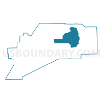
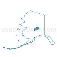
Healy Precinct, Denali Borough, Alaska
About
Outline

Summary
| Unique Area Identifier | 523301 |
| Name | Healy Precinct |
| County | Denali Borough |
| State | Alaska |
| Area (square miles) | 1,003.03 |
| Land Area (square miles) | 1,002.81 |
| Water Area (square miles) | 0.22 |
| % of Land Area | 99.98 |
| % of Water Area | 0.02 |
| Latitude of the Internal Point | 64.03075950 |
| Longtitude of the Internal Point | -148.47439480 |
Maps

Graphs
Select a template below for downloading or customizing gragh for Healy Precinct, Denali Borough, Alaska


Neighbors
Neighoring Voting District (by Name) Neighboring Voting District on the Map
- Cantwell Precinct, Denali Borough, AK
- Clear Precinct (Part; Also See Part In Yukon-Koyukuk Census Area), Denali Borough, AK
- Denali Park Precinct, Denali Borough, AK